Governance today is increasingly enacted through data. Decisions are not only informed by data, but structured, filtered, and justified through it.
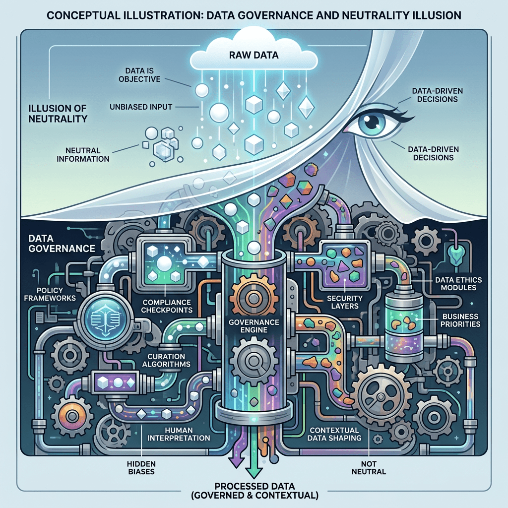
Data has become central to how governments understand territory, allocate resources, and justify decisions. In contemporary governance, data is often positioned as neutral evidence, a factual basis upon which policies can be rationally designed and implemented. Yet this assumption of neutrality deserves closer scrutiny. Data does not simply describe reality. It actively shapes how reality is defined, categorized, and governed.
Nowhere is this more evident than in the governance of land and space. Land is not only a physical asset. It is a site of economic value, social identity, and political power. When land is translated into data through mapping, registration, and digital systems, it becomes legible to institutions. However, this process of making land “visible” is neither neutral nor complete.
Data as Evidence and the Construction of Reality
In policy discourse, data is frequently treated as objective evidence. Spatial data, cadastral records, and geospatial systems are used to define boundaries, ownership, and land use. These datasets form the basis for planning, taxation, infrastructure development, and dispute resolution.
However, as Bowker and Star (1999) argue, classification systems are not neutral. They reflect choices about what to include, how to categorize, and what to prioritize. In the context of land governance, these choices determine whose claims are recognized and whose are excluded.
For example, formal land registration systems often prioritize documented ownership. Land that is occupied or used informally may not be captured in official datasets. As a result, entire communities can become invisible within formal governance systems, despite their longstanding presence.
This illustrates a critical point. Data does not simply represent land. It constructs a particular version of it.
Spatial Data and the Politics of Visibility
The use of geospatial technologies has significantly expanded the capacity of governments to map and manage land. Satellite imagery, geographic information systems, and digital cadastres enable detailed visualization of territory.
These tools are often presented as enhancing transparency and efficiency. Yet they also introduce new forms of power.
Visibility is not evenly distributed. Some spaces are highly mapped and monitored, while others remain partially or poorly represented. This uneven visibility affects how resources are allocated and how decisions are made.
Harvey (2006) emphasizes that spatial organization is deeply tied to power and capital. In a data driven context, this relationship is mediated through digital representations. What appears on the map becomes actionable. What does not appear risks being overlooked.
Data Systems and Administrative Authority
Digital land administration systems are increasingly used to streamline governance. Integrated databases, electronic land certificates, and spatial planning platforms promise efficiency and clarity.
However, these systems also centralize authority. Decisions about land are increasingly mediated through data infrastructures that are controlled by specific institutions.
Kitchin, Lauriault, and McArdle (2017) highlight that data infrastructures are socio technical systems embedded in institutional priorities. In land governance, this means that data systems reflect not only technical considerations, but also administrative logic and power structures.
This can lead to a situation where data driven decisions are perceived as neutral, even when they reflect particular interests or assumptions.
Illustrative Dynamics in Land Governance Practice
In practice, the tension between data and reality becomes visible in land administration processes.
Efforts to digitize land records and standardize spatial data often aim to improve legal certainty and reduce conflict. However, these processes can also reveal gaps between formal records and lived realities.
In many contexts, including those characterized by rapid urbanization and informal land use, official datasets may not fully capture the complexity of land tenure. Informal settlements, overlapping claims, and customary practices may exist outside formal systems.
When data is used as the primary basis for decision making, these complexities can be simplified or overlooked. Policies based on incomplete data may unintentionally disadvantage certain groups, reinforcing existing inequalities.
This dynamic is not unique to any one country. It reflects a broader challenge in translating complex social realities into structured data systems.
From Evidence to Power
The transformation of land into data also transforms the nature of power.
Data functions as a form of authority. Decisions supported by data are often seen as more legitimate, less subjective, and more difficult to challenge. This creates what can be described as evidentiary power.
However, this power is contingent on how data is produced and interpreted. Choices about data collection, modeling, and analysis shape outcomes. These choices are not purely technical. They involve judgments about relevance, accuracy, and priority.
Pasquale (2015) notes that complex data systems can obscure decision making processes, making it difficult to understand how conclusions are reached. In land governance, this opacity can limit accountability and reduce the ability of affected communities to contest decisions.
Rethinking Neutrality Through a Data Justice Lens
To move beyond the illusion of neutrality, it is necessary to adopt a data justice perspective.
Representation concerns which forms of land use and ownership are captured in data systems. When certain groups are underrepresented, their claims may be marginalized.
Distribution relates to how the benefits and burdens of land governance are allocated. Data driven decisions can shape access to land, infrastructure, and economic opportunities.
Governance addresses who controls data systems and how decisions are made. Concentration of control can limit transparency and participation.
These dimensions highlight that data is not simply a technical input. It is a site where questions of justice are negotiated.
Toward a More Reflexive Approach to Data and Land
Recognizing the limits of data does not mean rejecting its use. Instead, it calls for a more reflexive approach.
First, data should be understood as partial and situated. It provides valuable insights, but not a complete picture.
Second, decision making should incorporate multiple forms of knowledge, including local and experiential perspectives. This can help address gaps in formal data.
Third, transparency and accountability should be strengthened. Clear explanations of how data is used and how decisions are made are essential.
Finally, institutions should remain aware of the power embedded in data systems. Neutrality should not be assumed, but continuously questioned.
Conclusion
The governance of land and space in a data driven world cannot be understood through the lens of neutrality alone. Data shapes how land is seen, how decisions are made, and how power is exercised.
The challenge is not simply that data is used in governance, but that governance increasingly takes place through data. When this happens, neutrality becomes not a property of the system, but an assumption that must be continuously questioned.
By framing data as neutral evidence, there is a risk of overlooking the choices, assumptions, and exclusions that underpin it. Moving beyond neutrality requires recognizing that data is both a tool and a political construct.
From this perspective, the role of governance is not only to use data effectively, but to ensure that its use is aligned with principles of fairness, inclusiveness, and accountability.
As a reflective position, it is important to emphasize that the challenge is not the presence of data in governance, but the uncritical acceptance of its neutrality. A more just approach to land and spatial governance depends on our ability to question, interpret, and situate data within the broader context of power and society.
References
Bowker, G. C., and Star, S. L. (1999). Sorting Things Out. MIT Press.
Harvey, D. (2006). Spaces of Global Capitalism. Verso.
Kitchin, R., Lauriault, T., and McArdle, G. (2017). Data and the City. Routledge.
Pasquale, F. (2015). The Black Box Society. Harvard University Press.

Leave a comment